Reverse
Text France in seven languages on the periphery. Symbol of the currency of Paris at 12 o'clock. Various pictograms of the Centre des Monuments Nationaux converging towards the center.
Lettering:
FRANCE ~ FRANKREICH ~ 法国 ~ フランス ~ 2017 ~ فرنسا ~ FRANCIA ~ ФРАНЦИЯ ~
MONNAIE
DE PARIS
CENTRE
DES
MONUMENTS
NATIONAUX
Edge
Reeded
Comment
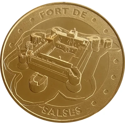
The narrow coastal strip of 200 meters wide located between the first foothills of the maritime Corbières and the pond of Leucate constituted an obligatory point of passage for any invading army wishing to pass from Languedoc to Roussillon. Indeed, if foot troops could eventually take the steep paths of the Corbières without too much difficulty and thus bypass this position by the heights, it was not the same for the heavy guns of the artillery and the innumerable carts of food, material and ammunition usually accompanying the armies on the march. The "plaine-goulet" of Salses was therefore an obligatory point of passage for these convoys and artillery teams, and the fortress was erected in the middle of it as a real lock controlling the passage. The geostrategic importance of the "goulet" of Salses has been attested to since ancient times by the passage of the Domitian Way and, in more recent times, by the passage of the RN9, the A9 freeway and the railway line from Narbonne to Port-Bou.
Https://en.wikipedia.org/wiki/Forteresse_de_SalsesThis is an automatic translation. The original text is:
L'étroite bande littorale de 200 mètres de large située entre les premiers contreforts des Corbières maritimes et l'Étang de Leucate constituait un point de passage obligé pour toute armée d'invasion désirant passer du Languedoc en Roussillon. En effet, si des troupes à pied pouvaient éventuellement emprunter sans trop de difficultés les chemins escarpés des Corbières et contourner ainsi cette position par les hauteurs, il n'en était pas de même des lourds canons de l'artillerie et des innombrables charrettes de vivres, de matériel et de munitions accompagnant habituellement les armées en marche. La « plaine-goulet » de Salses était donc pour ces convois et ces attelages d'artillerie un point de passage obligé au milieu duquel la forteresse fut érigée comme un véritable verrou contrôlant le passage. Cette importance géostratégique du « goulet » de Salses est attestée dès l'antiquité par le passage à proximité de la Voie Domitienne et, à une période bien plus récente par ceux de la RN 9, de l'autoroute A 9 et de la ligne de chemin de fer de Narbonne à Port-Bou.
Https://fr.wikipedia.org/wiki/Forteresse_de_Salses